|
 |
|
|
|
|---|
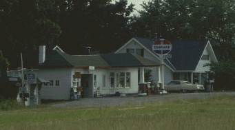
| 1928 Standard Station still going near Chillicothe, Missouri |
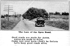
The Pikes Peak Ocean-to-Ocean Highway: it spanned the continent from New York City to Los Angeles in a time when paved roads were rare and traveling by car for more than 10 miles was an adventure. Going back to at least 1912, PP-OO blazes adorned power poles and trees across to center of the country, marking the route of this transcontinental highway. Begun by roads boosters who arranged with cities and towns along the route to participate in this form of civic advertising, the route was probably determined more by which towns would offer money and road improvement than any logical routing design.
Competing with its more famous cousins the Lincoln Highway and the National Old Trails Road well before the national numbered routes existed, the PP-OO, as its markers labeled it, has fallen into obscurity, virtually unknown even to residents of the cities and towns along the old route.
Why? One look at the municipalities it visited tells part of the story; if you had to design a cross-country road which avoided any major city, it would be hard to do better than the PP-OO. After leaving NYC, the biggest city it hit in the northeast was Harrisburg, PA. Studiously avoiding Columbus and Indianapolis, the route wound through one small town after another in the midwest, with Springfield, IL its major stop. Through the headquarters city of the PP-OO Highway Association in St. Joseph, MO, the trail skirted the northern edge of Kansas, turning south to avoid Denver it finally pulled into Colorado Springs, near its namesake mountain. Through numerous mountain and desert towns in Colorado and Utah, the main route hit Las Vegas - then a sleepy desert town - and veered south then west into San Bernardino and LA. In a time when gas stations and the ever-required auto repair shops were few and far between, this back-routing no doubt hurt the commercial viability of the road. Also contributing to its nearly forgotten status is the US government's finally getting into the highway business in 1926. While the Lincoln Highway was largely followed by the new US route 30 and the National Road became US 40, the PP-OO was given fragments of many routes, with many segments of the old road not assigned to a US route at all. Only US 36, a second tier east-west route (not a multiple of 10) in the federal numbering system, was associated with a major part of the old PP-OO through Ohio, Illinois, Missouri, and Kansas.
|
|---|
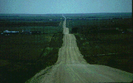
| Dirt road remnant in eastern Colorado |
On the other hand, such relative obscurity has left the old route more pristine than its former competitors which now are either largely overridden by Interstate highways, or have become heavily traveled, highly commercialized local routes. Re-tracing the old Ocean-to-Ocean road, one travels through the countryside, towns less impacted by urban and commercial sprawl, and comfortable smaller cities. It is not so hard to imagine what travel might have been like in the teens and twenties, following a narrow, roller-coaster road through north central Missouri, a winding mountain road in eastern Pennsylvania, an arrow-straight two-lane through the cornfields of central Illinois, or an abandoned gravel segment in western Kansas. The road takes you through the forested hills of the northeast, the agricultural heartland, the back country mountain and desert west. Some of the best of America.
It is for these reasons that we developed this website. To help uncover some of the history of road travel, to spread the word of the remnants of the road, to open some eyes, perhaps, to the forgotten places still there along the road. The developers welcome any comments and information you might have on the PP-OO. We are not historians or geographers, and have only begun our journey on the old road. Like travelers in the early days, we appreciate any news of the road ahead.
|
|---|
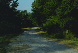
| Shady abandoned segment in western Illinois |
The route of the highway evolved significantly over the years between 1914 and
1926 when the federal numbering system began. In the early days the PP-OO
highway followed the same route as the National Old Trails Road in the East,
beginning in Washington, D.C. and New York. The western terminus was San
Francisco. By 1923, New York was the sole eastern end and Los Angeles had
replaced San Francisco in the west. Numerous local re-routings occured as well.
The Eastern changes
appear to be an deliberate attempt to distinguish the PP-OO highway from the
National Old Trails route which it originally followed. There may have been similar
reasons behind the western change since the early route overlapped the Lincoln
Highway. Documents from 1915-16 show the PP-OO Association actively searching for
a unique route in Utah and Nevada and soliciting suggestions and participation from
state governors. Such route changes are not rare with highways and continue to this
day. For example, the successor to the PP-OO in Illinois, US 36, was re-routed to the
north in the 1990's in the western part of the state and turned into a limited
access highway. At the dawn of the motor age a local re-routing may be due simply
to the original road becoming impassable or because a town on the route chose not
participate in the required boosterism.
|
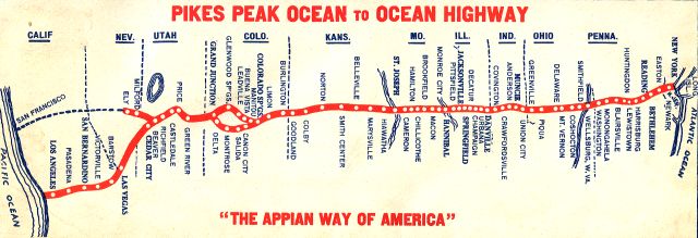
|---|
| The route from a 1923 guide to the PP-OO Highway |
We present the route for the mid-1920's in the following links (some are under construction - sorry, try back later). For an earlier route, from 1915, see the Federal Highway Administration PP-OO site.
|